|
|
|
Where
is Kakadu National Park
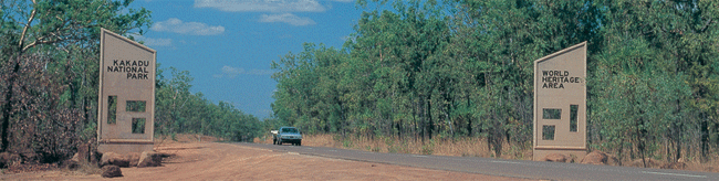
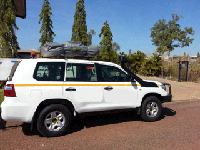
Kakadu National Park an Australian Natural
Icon covers almost 20,000 square kms and is 253
kms East of Darwin the capital city of the Northern
Territory, Australia. Kakadu National Park is a World Heritage
listed area that has been listed for it's cultural
and natural heritage and Kakadu is the largest
terrestrial national park in Australia. Life
in the park does depends on the water, also in
respect to the tropical monsoon climate that produces
the downpours of the tropical humidity of the
"wet" season, and the milder weather of the "dry"
season.
Kakadu National Park is
the gateway to Arnhemland. The sealed roads
from Darwin to Kakadu is via the Arnhem Highway
and from Katherine to Kakadu National Park via
the Kakadu Highway. The Bowali
Visitor Centre near Jabiru
in Kakadu National Park is located 253 km
from Darwin in Northern
Territory Australia via the Arnhem
Highway entrance. If travelling by road,
you should allow 3 hours travelling time from
Darwin.
Kakadu is the second largest
national park in the world and and is home to
approximate number of species: Mammals: 62,
Reptiles: 123+, Birds: 280, Freshwater Fish:
51, Insects: 10,000, Frogs: 25, Plants: 1,275.
(many are rare and occur only in Kakadu)
|
 |
Kakadu
National Park - Seasons
But Australia's Kakadu sees seasons of varied
extremes -- so varied, in fact, that the park's
longtime aboriginal inhabitants have divided
the year into six distinct seasons.
|
|
Gunumeleng Pre-Monsoon Storm Season
Gunumeleng, from mid-October to late December,
may in fact last from a few weeks to several months.
It is the pre-monsoon season of hot weather that
becomes more and more humid. Thunderstorms build
in the afternoons and scattered showers bring
a tinge of green to the dry land. As the streams
begin to run, acidic water that washes from the
floodplains can cause fish to die in billabongs
with low oxygen levels. Waterbirds spread out
as surface water and new growth become more widespread.
Barramundi move from the waterholes downstream
to the estuaries to breed. This was when Bininj/Mungguy
moved camp from the floodplains to the stone country,
to shelter from the violent storms of the coming
wet season. |
Gudjewg - Monsoon Season
Gudjewg, from January to March, can be described
as the 'true' wet season. It is a time of thunderstorms,
heavy rain and flooding. The heat and humidity
generate an explosion of plant and animal life.
Spear grass grows to over 2 metres tall and creates
a silvery-green hue throughout the woodlands.
Magpie geese nest in the sedgelands. Flooding
may cause goannas, snakes and rats to seek refuge
in the trees. Eggs and stranded animals are a
good food source for Bininj/Mungguy during this
time. |
Banggereng - Knock 'em down storm Season
Banggerreng, in April, is the season when the
rain clouds have dispersed and clear skies prevail.
The vast expanses of floodwater recede and streams
start to run clear. Most plants are fruiting and
animals are caring for their young. Violent, windy
storms early in this season flatten the spear
grass; they are called 'knock 'em down' storms.
|
Yegge - Cooler but still humid Season
Yegge, from May to mid-June, is relatively cool
with low humidity. Early morning mists hang low
over the plains and waterholes. The shallow wetlands
and billabongs are carpeted with water lilies.
Drying winds and flowering Darwin woolly butt
tell Bininj/Mungguy that it is time to start burning
the woodlands in patches to 'clean the country'
and encourage new growth for grazing animals.
|
Wurrgeng - Cold Weather Season
Wurrgeng, from mid-June to mid-August, is the
'cold weather' time; humidity is low, daytime
temperatures are around 30°C and night-time temperatures
are around 17°C. Most creeks stop flowing and
the floodplains quickly dry out. Burning continues,
extinguished by the dew at night. By day, birds
of prey patrol the fire lines as insects and small
animals try to escape the flames. Magpie geese,
fat and heavy after weeks of abundant food, and
a myriad of other waterbirds crowd the shrinking
billabongs. |
Gurrung - Hot Dry Weather
Gurrung, from mid-August to mid-October, is hot
and dry. It is still 'goose time' but also time
for Bininj/Mungguy to hunt file snakes and long-necked
turtles. Sea turtles lay their eggs on the sandy
beaches of Field Island and West Alligator Head
and goann as rob their nests sometimes. White-breasted
wood swallows arrive as thunderclouds build, signalling
the return of Gunumeleng. |
|
The Climate of the Kakadu Region
Kakadu is located in the tropics, 12 to 14°
south of the Equator.
The climate is monsoonal, characterised by
two major seasons: the dry season and the wet
season. The 'build up' describes the transition
between these two seasons.
During the dry season (April/May to September),
dry southerly and easterly trade winds predominate.
Humidity is relatively low and rain is very
unusual.
At Jabiru the average maximum temperature for
June-July is 32°C. During the 'build up' (October
to December) conditions can be extremely uncomfortable
with high temperatures and high humidity.
However 'build up' storms are impressive and
lightning strikes are frequent. In fact the
Top End of Australia records more lighting strikes
per year than any other place on earth.
At Jabiru the average maximum temperature for
October is 37.5°C.
The wet season (January to March/April) is
characterised by warm temperatures and, as one
would expect, rain.
Most of the rain is associated with monsoonal
troughs formed over Southeast Asia, although
occasionally tropical cyclones produce intense
heavy rain over localised areas.
At Jabiru the average maximum temperature for
January is 33°C.
Annual rainfall in Kakadu National Park ranges
from 1,565 mm in Jabiru to 1,300 mm in the Mary
River region.
The following charts provide an indication
of rainfall, temperatures and humidity within
the Kakadu region. Data for the charts was sourced
from the Bureau of Meteorology, Darwin.
The offical website is www.kakadunationalpark.com
our extenisve own website
|
|
|
|
|
Litchfield
National Park features numerous waterfalls which
cascade from a sandstone plateau called the Tabletop
Range, monsoon rainforests, intriguing magnetic
termite mounds and historical sites.
Litchfield National Park lies approximately 130km's
southwest of Darwin near the town of Batchelor and
covers around 1,500 sq km's.
|
|
Kakadu National
Park an Australian Natural Icon covers almost 20,000
square kms and is 257 kms East of Darwin the capital
city of the Northern Territory, Australia.
Kakadu National
Park gateway to Arnhemland.
The sealed roads
from Darwin to Kakadu is via the Arnhem Highway and
from Katherine to Kakadu
National Park via the Kakadu Highway.
A Kakadu National Park tourist travel
information guide, visiting and staying in Kakadu,
around and about Kakadu National Park with tropical
Darwin the capital of Northern Territory Australia
just 253klm away to the Kakadu entrane via the Arnhem
Highway. If travelling by road, you should allow 3
hours travelling time from Darwin. Maps of the road
to Kakadu and of Kakadu
National Park.
|
| • Katherine:
A lush tropical wonderland, the Katherine region is
most famous for the spectacular Katherine Gorge in
Nitmiluk National Park. Just one of 13 stunning gorges
carved into the Arnhem Land plateau by the Katherine
River, a cruise through Katherine Gorge is truly unforgettable.
|
|